G for Gard family

Thanks to David Gard for writing this post for the A-Z challenge.

Blue links will take you to the digitized images from Libraries Tasmania website or newspaper articles from National Library website Trove. Clicking on the images will take you to the original article.

WILLIAM GARD, my great great grandfather was born in the village of Allington, Dorset, England in 1815. It is not sure when or how he immigrated to Australia but he was the only one of the seven (7) children in his family to migrate. His father Edward 1789-1823, a stone mason died in Dorset, England when he was only eight.

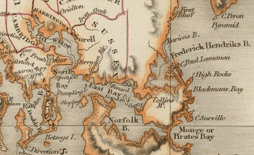
William somehow made his way to Pittwater, Tasmania (now Sorell) where he became one of the largest land holders in town, but after receiving more than his share of bad luck he was forced on a number of occasions to liquidate his assets. However, through sheer determination he managed to rebuild on each occasion.

His grandfather, Robert Gard was transported to Van Diemen’s Land as a convict in 1818 and buried in Richmond district in 1834 which would have been a few years prior to William arriving in the colony. He also had a brother, Joseph who was transported to Tasmania as a convict in 1838 and was pardoned in 1847. Joseph died in Sorell in 1866. It is not known whether they reunited. Williams uncle, Thomas Bennett Gard was also transported to Van Diemen’s land in 1822 after a reprieve from the death penalty and like his father Robert he was assigned to magistrate James Gordon to work his farm in Pittwater.

William was described as a hard working industrious colonist and built quite a large portfolio of properties and ran a number of business ventures in Sorell. He was on the board of the Sorell Causeway committee and a member of the Clarence council, and a justice of peace. A large farm he leased with a business partner Henry Clack was dissolved in 1840 when William ran off with Henry Clacks wife, Mary Ann Clack (nee Parsons) who he later married in 1848.

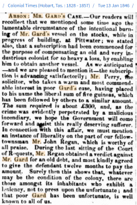
Williams financial troubles started in 1843 when he was declared insolvent and was forced to sell off much of his assets. After a 2 year struggle to re-build, a trading vessel he owned was maliciously set on fire (could it have been lit by Henry Clack ?) The Sorell community, which held him in very high esteem called on the government to assist him with his losses and help him obtain another vessel which he intended to trade between Hobart Town and Adelaide.

Community help after an arson attack


In 1853 William managed to purchased the towns iconic Bell Bell Inn, but his bad run of luck started again where in 1863 when another large fire destroyed the Inn and he lost all his possessions. He managed to raise a mortgage of 2000 pounds to re-build the inn however the financial strain was too much and for the second time he was declared insolvent and the Inn was passed back to the mortgagee, William Lindsay.

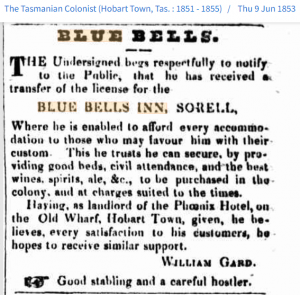
In 1855 William experienced another devastating fire on his farming property where he lost a large stock pile of wheat, grain, barley, oats and peas as well as live stock. William had not taken out insurance because of the way he was treated by the insurance company after the fire that destroyed the Blue Bell Inn 2 years earlier.

In 1864 his entire property holding of fifteen (15) properties in Sorell were put up for sale however because of his debts, it is not known whether he had any equity left after the sales. Lindsay died in 1866 and the Blue Bell Inn was put up for a quick sale and it was purchased by William Gard’s son, Edward (our great grandfather) for a bargain price of 300 pounds. Edward also experienced financial difficulties when he was forced to raise a further mortgage of 180 pounds. In 1869 Edward defaulted on the mortgage and lost possession of the Inn.

On 7 February 1867 William passed away in Sorell with cause of death noted as gout.

In 1874 Edward again managed to regain the family inn but found the financial burden too much and again after a short period of time he lost possession thus sadly ending the Gard connection with the Inn.

F for First People

Thanks to Melinda Reed for writing this post for the A-Z challenge. These words are adapted from articles in Pitt Water Chronicles Vol 1 and Vol 3 published by the Sorell Historical Society.   Blue links will take you to websites for further information.

Sign at Blue Lagoon area

The first people of the land and coastline we now know as Sorell Municipality were the Mumirimina people of the Oyster Bay nation, who lived here for 2000 generations until dispossessed of their home.

Thick forests and grassy plains provided an abundance of animals to hunt, shells and kelp gathered from the ocean beaches, river reeds and other foods collected along the river banks. Women made reed and kelp baskets and collected ochre to decorate hair, faces and bodies. Necklaces were made of wallaby sinews and ochre, or strips of fur or of shells strung on sinews or string made from reeds. Deep spiritual beliefs and an enduring culture evolved over 40,000 years.

Then in 1642 Oyster Bay people watched Tasman’s ships, and in 1772 encountered French ships and explorers who killed one Aboriginal man. In 1803 life changed drastically with the arrival of the British and the rapid colonisation of the south east.

In 1809 Mumirimina man John Shinall (Shiney, Aboriginal name unknown) was born in the Carlton area, living a tribal life with his family until land grants in that area from 1812, then lived with a settler family and later worked as a farm labourer.

Between 1815 and 1819 an Aboriginal ‘mob’ traversed between Risdon and Pitt Water in the summer and retired to the east coast in winter, including a camp at Sweetwater Hills at Penna.

On 9 December 1826, fourteen Oyster Bay Aborigines were believed killed and nine others, including Kickerterpoller, were captured and lodged in the Sorell gaol.

In 1828 Governor Arthur declared martial law against the Aboriginal people and in December 1830 Sorell settlers took part in the Black Line.

In the 1830s George Robinson documented the Oyster Bay word tipina, the name for what is now Midway Point. It is the only recorded Aboriginal place name in the Sorell area.

On his death in 1839, John Shinall was mutilated and his severed head preserved in alcohol; eventually returned from Dublin University to the Tasmanian Aboriginal people in 1990.

Today, in commemorating 200 years since the naming of Sorell township, we respectfully acknowledge this always was and always will be Aboriginal land. The ancient stewardship of the land and coastline continues in the unique culture of the Palawa/Pakana (Tasmanian Aboriginal people), one of the world’s oldest living cultures.

Image source: Owned by Melinda Reed, author of this post

E is for Early Explorers

On the timeline for this blog is  a list of early explorers of the district. In this post I am going to look at those sea explorers who visited.

Abel Tasman 1642

He was a very well known sea explorer and in 2017, there were many celebrations held in the community relating to Abel Tasman and his voyage to Van Diemen’s Land. A post written on the Sorell History Society blog shows how his voyage affected the municipality of Sorell. Tasman’s voyage included setting foot on the land and seeing clouds of smoke, but no meeting of the Aboriginal tribes.

Marion du Fresne 1772

Many men on his voyage kept journals which included the first encounters Europeans had with Aboriginal people.  These can be found on the Australia on the map website. This site also includes information from Abel Tasman journals.

These two explorers dropped anchor in what we call Blackman Bay (Marion Bay) nowadays but was originally called Frederick Henrik Bay. Due to poor mapping of southern Van Diemen’s Land, many errors were made when naming bays in the municipality.

Bruni D’Entrecasteaux 1792-1793

He anchored in Storm Bay in 1792 and while the crew looked after the ship, he mapped much of the southern coast. On a second visit in 1793, he examined more of Storm Bay, particularly the northern section including what was to be known as Riviere du Nord or Derwent River in future years.

George Bass and Matthew Flinders 1798

As part of their circumnavigation of Van Diemen’s Land, Bass and Flinders mapped and named more of southern VDL including Storm Bay and the Derwent estuary. On Christmas Day, Bass climbed Mount Table now known as Mount Wellington. Norfolk Bay was given its name by Flinders after the boat they were using on their voyage.

Nicholas Baudin 1802

By January 1802, Baudin was mapping more of the coastline (see maps) that had already been done by Bass and Flinders. So this is where many places ended up with two different names. Pierre Faure was a French geographer who travelled with Baudin and charted and named Carlton River (Riviere Brue) and Pittwater (Basin Ransonnet).


Map of the municipality
Publisher: Hall, S. (Sidney) 1828

Image Credit: Click on map to go to original

“David Rumsey Map Collection, David Rumsey Map Center, Stanford Libraries”