L for Land grants and LISTmap

I wrote a previous post about the early land grants in the municipality. But if you want to find exactly where the grants of land were a good spot to start with is the website called The LIST.  The website is part of the Department of Natural Resources and Environment Tasmania.

LIST stands for Land Information System Tasmania.

Please note I am using Chrome browser – PDF linked below mentions other browsers.

Step by step instructions when using LISTmap. PDF from their help area also useful.

  1. Clicking on LISTmap will take you to a map of Tasmania.
  2. On the far left are bars for zooming in or out but you can also use scroll bar on mouse or double click on mouse to do the same thing.
  3. Still on top left, the tools bar allows you to make marks on your map if you are then going to share and or print. These are explained on page 17+of the help PDF.
  4. Top right corner of the map shows basemap and layers. It is here where you look for your land grant.
  5. I generally leave the base map as it is when loaded as it shows present day roads and places which will help if you eventually want to visit the land grant.
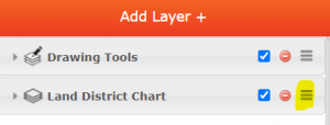
  6. Click on Layers then Add layer in top right corner of map
  7. You now have a list of layers to manage. To find Tasmanian land grants, scroll down to Imagery and Maps
  8. One of the minor categories there is Historic Maps and Charts. Click on that.
  9. You now have 4 layers to choose from. Click the green + sign next to the first choice – Land District Chart
  10. Close the Manage Layers by clicking on the X
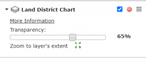
  11. You can now see Land District Charts are over the top of your original basemap.

But how do you now find your particular land grant?

By clicking the three lines highlighted above, you now have a transparency bar to use. This will make either your basemap most transparent or your land chart most transparent. Just move the little bar along the line. At about 65% you should be able to see a lot of the basemap as well as very blurry land charts.

It is now time to zoom in to the place you are looking for eg Sorell, Carlton, Dodges Ferry etc.

How do you know exactly where to look?

Use the land grant post to find a name of an early settler you would like to search for.

You can also use the Libraries Tasmania website, family history portal then Tasmanian Names Index. Put in name of settler, then filter on the left for land records. Then click on the cover image and you will have something like below.

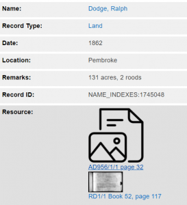
The first resource beginning AD is a list of names being given land grants each year.

The second resource RD is the actual paper work for that specific piece of land. It often mentions a lot number as well as the owners or leasees of adjoining pieces of land. This will help you find the exact spot for your settlers land.

Readers: How did you go finding a land grant given to one of your ancestors?

Early properties

Pezibear / Pixabay

By 1806 the first farms were under cultivation in Gloucester as Sorell district was then known. Early land grants were given in 1812 to the following:

Robert Alloms or Allomes Charles Anthony William Baxter Jacob Billett or Bellette
John or James Birchall Richard Buckingham James Davies Frederick Dawes
J. Duncombe William Fenner Arnold Fisk Mary Fogarty
Silas Gatehouse James Grimes William Hambly James Hannaway
Jane Hobbs William Hopley Jane Horton (Gill), A.W.H.Humphrey
John Ingle Charles Jeffries Thomas Kent John Knox
Alexander Laing I. Larsome John Liddle David Lord
Edward Lord R. W. Loane William McDowall John Miles
George Morrisby Robert Nash Thomas Pennington J. Prestage
Bartholomew Reardon Walter Redpath Mary Richardson Thomas Riley
S. Sederick James Turnbull John Wade M. Wicks
Charles Willis J. Wilson William Wilson W. Wood
Thomas Richardson Thomas Solly?

Sorell was a big farming community.  They transported crops and vegetables to neighbouring parishes to sell at markets. There were two wind mills called Nash windmill and Downwards windmill. Farming was an important part of Sorell history and the main thing that Sorell farmed was wheat and most of the wheat was transported to Sydney.

In 1815, so much wheat was being produced that a flour mill was built by Robert Nash.

John Birchall of Marsh Farm, began in 1816 a wheat delivery service from Pittwater to Kangaroo Point on his new schooner ‘Young William‘ at a rate of 1/6 a bushell.

In south, sheep dominated the Bream Creek area around the coastal flats with dairying the preferred industry on the rich basalt soils of the Ragged tier and at Nugent. Dairy properties were generally small family’s properties with produce being sold to the Bream Creek butter factory from 1899. Pigs were also raised at Bream Creek and sold at the Sorell sale yards.

Land grants

It was in 1803 that James Meehan, a surveyor of the time, first passed through the district now known as Sorell. On one of his trips, he was reported as exploring north west of the Coal River and returning by way of Prosser’s Plains and the Sorell district. He was the first non-aboriginal to travel in this direction and the range of hills between the Derwent River and Sorell municipality now bear his name.

Until 1821, the district was known as Pittwater, but it is uncertain how this name came about. Perhaps it was named after William Pitt, the Chancellor of the Exchequer in England. Perhaps it was named after an early settler, Thomas Pitt, who visited the district in 1804. James Meehan knew of Pitt’s interest and often referred to the area as Pittwater.

In 1805 George Prideaux Harris was sent by Lieutenant David Collins to survey the Pittwater area. He had high hopes for a fine harbour with a lovely city on its banks but was disappointed when the report mentioned shallow water and not suitable for a harbour.

By 1806 the first farms were under cultivation in Gloucester as Sorell district was then known. The first land grants were confirmed by Governor Macquarie in 1812 to the following people:

Robert Alloms or Allomes Charles Anthony William Baxter Jacob Billett or Bellette
John or James Birchall Richard Buckingham James Davies Frederick Dawes
J. Duncombe William Fenner Arnold Fisk Mary Fogarty
Silas Gatehouse James Grimes William Hambly James Hannaway
Jane Hobbs William Hopley Jane Horton (Gill), A.W.H.Humphrey
John Ingle Charles Jeffries Thomas Kent John Knox
Alexander Laing I. Larsome John Liddle David Lord
Edward Lord R. W. Loane William McDowall John Miles
George Morrisby Robert Nash Thomas Pennington J. Prestage
Bartholomew Reardon Walter Redpath Mary Richardson Thomas Riley
S. Sederick James Turnbull John Wade M. Wicks
Charles Willis J. Wilson William Wilson W. Wood
Thomas Richardson Thomas Solly?

By 1815, so much wheat was being produced that a flour mill was built by Robert Nash and a year later a site for a township was purchased. This site was originally part of a grant given to John Clarke, then sold to James Gordon, who further sold it to Thomas Archer who immediately sold it to the Government at an advance of £150-0-0 (CSO1/301/7306 at archives of Tasmania)

In the Hobart Town Gazettes of 1816-1818 Nash, Allomes, Gordon, Hannaway, Birchall and Thorne had their goods advertised by creditors. In the same period, the editor of the Gazette placed reminders that subscribers of Pittwater and other parts of the country who were up to three years in arrears with subscriptions could make payment in wheat. Goods were often exchanged because currency was often in short supply.

John Birchall of Marsh Farm, began in 1816 a wheat delivery service from Pittwater to Kangaroo Point on his new schooner ‘Young William’ at a rate of 1/6 a bushell. He offered a free delivery for those who wished to contribute to the fund for the relief of relatives of those wounded at the battle of Waterloo.

By 1819 there were 9 residents but there were about sixty farms in the district which was now known as “The Granary of Australia.”

More land grants were given in 1824 and the municipality had been divided into four areas.
G – Gloucester – Sorell, Pawleena and surrounds

Robert Allums William Baxter Jacob Billett John Birchall Mr Buckingham
Mr Burchall James Davis John Duncombe Arnold Fish (Fisk) Mr Fogherty
Mr Gatehouse Government Mr Gregory William Hambly jun William Hambly sen
A.W.H. Humphrey William Jenner Thomas Kent Roland W Loane Richard Loisonce
Mr E Lord Peter Mills George Morrisby Robert Nash Thomas Pennington
Thomas Prestage Bartholomew Reardon Walter Redpath Mr Riley Samuel Sedrick
John Wade Charles Willis Mr Wilson

H – Harrington – Midway Point, Orielton

Richard Coleman John Hatcher John Ingle Lieut Charles Jeffries James Lord
Mr D Lord Mr Martin Horatio William Mason James Mayberry John Palmer Stone
Dr Henry St John Younge

P – Pitt – Pittwater

Mr Champion Mr Kelly James Kelly Mr Roberts

S – Sussex – Forcett, Dodges Ferry and surrounds

Nathaniel Ayres Thomas Bowden Riley Buckingham Mr Clark Walter Colquhoun
Mr Crowder Mary Geils James Gordon James Hannaway Jane Hobbs
Rachael Hoddy John Hulan Thomas Allen Lacelles John Lakeland Joseph Pendill
William Rayner(or) jun William Rayner(or) sen George Raynor Bartholomew Reardon Mr Redpath
Isabella Riley Thomas Riley sen Thomas Riley jun Mr Scott William Shirley
Ann Shuttleworth Mr Smith Mr Steel John Tapley Mr Waddel (Alex Stewart Waddle)
John Welch Samuel Westlake William Woolley

The Tasmanian Archives has many links to land grants in the state and they can be found here. Some are online and others you need to visit or contact the Archives.

To find out more about land settlement in Tasmania, the UTAS eprints has a PDF available here.