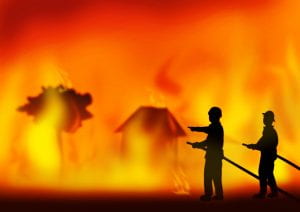
Here in Tasmania, our worst disaster is caused by bushfires or fires that have got out of control. When we have a wet winter and spring, then a dry summer and the lush grasses and undergrowth start dying and going brown, then we know we could be in for a terrible fire season. Much of our land is protected forest or used as farmland with crops and animals. Our forests are predominantly Eucalyptus species which catch alight quickly and the burning leaves and bark leap ahead of the main fire front especially if backed by heavy winds. This will cause lots of spot fires which then develop into larger fires.
When I was 11 years old, I lived in Glenorchy on the western shore of Hobart and saw the effects of the 7 February 1967 bushfires on the slopes of Mt Wellington. In total, 64 people lost their lives, 900 were injured and about 7000 left homeless across the state. About 1400 homes were destroyed and a further 128 buildings included schools, halls, churches. There were 110 fire fronts burning over 652,000 acres of land within a five hour period. The local paper The Mercury put together a 50th anniversary booklet including memories from the south east of Tasmania. Just today I was shown a link to a Facebook post celebrating the 54th anniversary of the Black Tuesday bushfires. These fires also affected the municipality of Sorell. Read about some memories further down this post.
Another disastrous fire season was in January 2013 when the township of Dunalley in the southern section of the municipality was virtually burnt to the ground. There were 40 fires burning across the state and more than 49000 acres of bushland were burnt out. Dunalley had 65 buildings lost to the fire including the police station, primary school and bakery. People from the Tasman and Forestier Peninsulas had to evacuate as the fire was bearing down on them from the north.
History of bush fires in the district
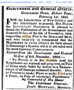
Researching this topic, I found as early as 1804 (the year after Van Diemens Land was first settled) the Lieutenant Governor was warning people about burning the stubble on their land.
In 1841, one fire was thought to be started by a convict road party but when requested verbally to help fight the fire, the overseer refused as it was not a requisition in writing.
By 1844 many settlers were taking out fire insurance for their houses and property.
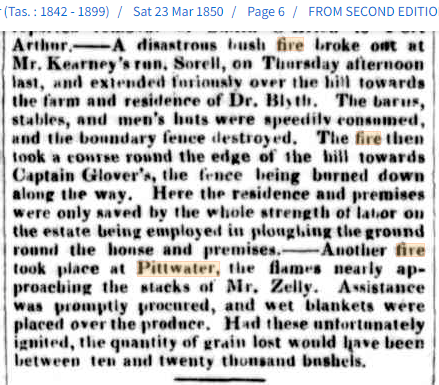
In March 1850, a fire in the district affected property owned by the following families: Kearney, Blyth, Glover and Zelly.
January 1854 another conflagration was mentioned in the local paper. Some of the surnames mentioned were: Morrison, Phipps, Wicks, Wright, White, Burslem, Bellett, Grimes and Blyth.
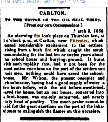
In March 1856, a fire at Carlton mentioned the extra undergrowth that caused the bushfire to burn quickly onto the local property.
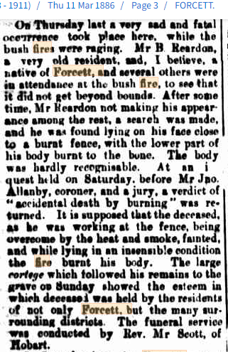
Some people lost their lives while helping to fight fires. Mentioned in March 1886 is that of Mr B Reardon, an old resident of Forcett, who while fixing a fence, must have been overcome with smoke and heat, fainted and the fire then went over the body.
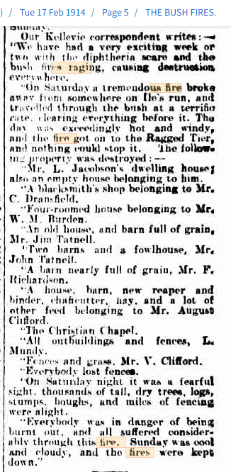
In February 1914, there must have been many fires in southern Tasmania, including around Kellevie and Carlton River. Many buildings destroyed and this was the second bushfire that season.

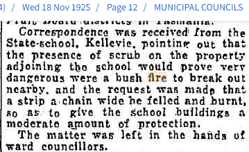
Council meetings such as this one in 1925, often mentioned the role council had in keeping drains, culverts and blocks of land clear in case of bushfires. Another meeting in 1930, discussed the availability of fire plugs in the town of Sorell. Councillor McDermott made an objection and a few comments from other members came straight to the point.
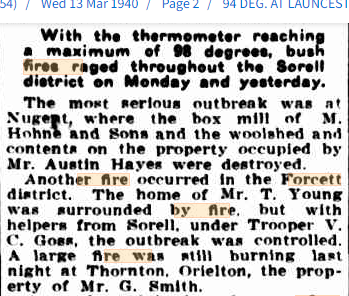
With the temperature reaching 98 degrees in Sorell in March 1940, some buildings on properties were again affected by bush fires.
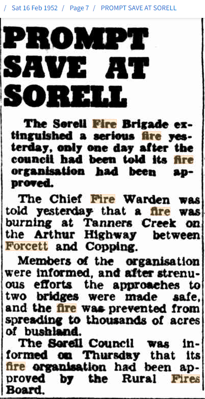
By 1952, Sorell had its own fire brigade and only one day after being approved by the Rural Fires Board, it was out protecting property from a large fire in the Forcett area.
Memories about Black Tuesday around the Sorell district from members of the Sorell Historical Society
RN: people say the old man (Trakka Newitt) saved Sorell…he back burnt the racecourse before the fire front hit….well before back burning was in vogue…..he learned it from his time on Bathurst Island with an Aboriginal tribe….now that’s a story in itself…… I remember a lot about the ’67 fires……..
LR: my mum told me the circus was in town and the kids from the school were ushered down to the causeway to stand in the water with the circus animals
RN: I remember they took us out of school, we were put onto buses in Forcett street and taken down to the causeway…we got off the bus and sat on the rocks….it was like a movie scene right in front of us…..the smell of burning sheep I remember
LD: The smell is what lingers in my memory too and the mounds in the paddocks that lingered for years
- LD: My dad was one of the Sorell residents that perished in the 67 fires . Fred Weil aged 39, he would have been 93 this month.
- GB: Yes, Fred and Geoff Davis(father of Neil Davis) both perished together fighting the fires out Shark Point Road, Penna.
- LD: I remember being told that dad and Geoff were found together dad facing the flames and Geoff facing away. Apparently dad went back to get Geoff after he had collapsed.
- LL: Think you will find that Geoff Davis and Manfred Weil died fighting the fires on my father’s property at Penna which was called Preston
LR: My mum was in Hobart and on the bus on the way back, they were stopped at Mount Rumney and told that Sorell and Midway Point was gone. I was 2 months old, my sister was one and learnt to walk that day
KC: I remember the 67 fires like it was yesterday. From being down at Park Beach swimming and getting home at lunch time. After going to the causeway because it was so hot, my friend and I noticed ash falling from the sky, we decided to go to our homes. When I got to the Blue Bell Inn (which was our home, my father was Allan Newitt) I went up stairs to the kitchen and Dad had been eating lunch. You can see Reynolds Hill from the window and dad had seen the fire coming from that direction. So he and Len Tapp who was staying with us went down and lit the race course because the fire would have jumped Arthur St and the whole of Sorell would have gone. I went up to the primary school and found Dad, he could hardly see out of his eyes for the smoke. The fire had come up behind the primary school. Dad asked me to drive him and the local police man back near where the sale yards used to be. We went down Pelham St to the Arthur Highway. I was scared because I didn’t have a licence but when I said this to the policeman he just said that I had done a good job girlie. Then Dad wanted to go to Penna and when we got there, there was all these poor sheep all charred and burnt. There were some local lads hanging about so Dad got them to help him to put the sheep down. The only thing that Dad found was an old railway spike to use to put them down with. It was an awful sight but Dad did the only thing he could to put them out of their misery. That’s what I remember about the 67 fires.
Readers: What has been your memory of bushfires or a disaster in your area of the world?