P for Photography

Albert Archer Rollings was born on 24 March 1865 to parents James and Martha Rollings (nee Wiggins).

In 1888, he was elected as secretary of the Lower Sorell road trust.

On 4 June 1890 he married Sophia Dodge, youngest daughter of Ralph Dodge, in Hobart.

In 1894, Arch was selling off a lot of goods at Rosy Vanyan, Forcett, the property owned by his parents who had both passed.

By 1895, Arch was the manager of the Forcett Milk Company operating from 78 Murray Street, Hobart.  In 1898, he was now manager of the Country Milk Supply Company and he was sent to Sydney to scope out how milk was supplied to customers there. Arch was present in 1917 when the Primary Producers Union was formed.

He was appointed post-master and savings bank agent at Forcett in 1896 after his sister Kate resigned.

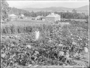
In the late 1890’s, Arch had a photography business in Harrington Street, Hobart with his partner Harry Dart. In the early 1900’s he sold his part of the business and moved to Sorell where he set up his own shop. He also had a partnership with H E Howard until 1906.

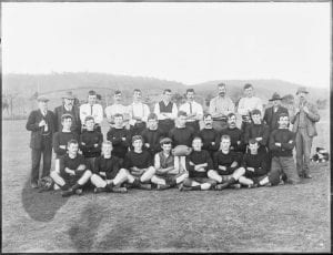
Arch was a member of the Sorell cricket club and often mentioned in reports. In 1914, he donated pendants as trophies for cricket. In 1916, he was secretary of the re-organized Sorell Rifle Club and by 1921 Arch was captain of the Sorell Rifle Club  also donating a trophy that year.

When a public meeting was held in August 1915, Arch used his skills to throw the anthems of the Allies onto a screen so everyone could join with the choir in singing.

In November 1922, Arch was selling his drapery business in Sorell. Sophia Rollings died on 28 September 1928. Arch remarried to Julia Adelaide Rapp. He died on 2 March 1947.

As Rollings and his wives had no children, the business was up for auction in the late 1950’s when the second Mrs Rollings died.

Robert Tanner, a former Sorell history teacher and a resident of Sorell, was attending the viewing for the auction of the Rollings business in Sorell. He noticed an old dunny (outhouse) in the backyard, looked inside and found it had been used as a dark room. It contained lots of boxes filled with glass plate negatives. He thought these could be used as part of his grade 7 local history studies at school. There was no lot number, so the auctioneer added a number. On the day of the auction, Robert was teaching, so a friend bid for him and it cost 10 shillings and 6 pence. A lot in the late 1950’s.

Robert and some of the older residents of Sorell could name people in the photos, so they were then sent to the Tasmanian Archives where they are now held. To listen to the ABC interview of Robert, follow this link. Also find out more about the discovery by reading Robert’s article in Pitt Water Chronicles Vol 2 (p39-42).

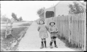
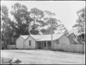
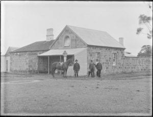
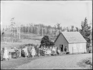
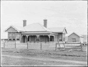
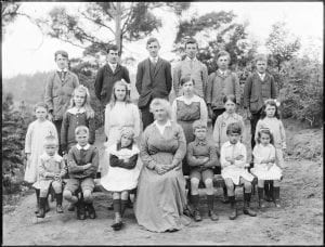
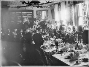
Below is a selection of the first 100 images of Arch Rollings negatives now digitized by the Tasmanian Archives.

NS1553-1-1 Forcett football team
NS1553-1-45 Eileen (Blossom) and George Ward wearing their grandfather’s shoes Joseph Green
NS1553-1-52 Forcett shop and Post Office owned by Mrs Bailey
NS1553-1-57 Sorell Council Chambers, Court and Gaol demolished 1910
NS1553-1-61 Ferry “Cartela” at Lewisham jetty
NS1553-1-68 Mrs Hacks wedding – Nugent church
NS1553-1-73 House, Gordon St, Sorell formerly owned by G and L Phillips, later Strides Drapery
NS1553-1-74 Mrs/Miss Howard and students at Wattle Hill School
NS1553-1-91 Sorell Council dinner
NS1553-1-98 Madsens property, The Ferns, Wattle Hill

O for Orielton Lagoon

The lagoon at Pittwater – Orielton is a Ramsar site which looks at over 2000 wetlands around the world. It was designated as a wetland 40 years ago this year.

Wetlands

Map created using theLIST – LISTmap – layer Reserves and Administrative Boundaries – then adding Reserves – Ramsar wetlands.

The wetlands have four main river/rivulet/creeks entering into the estuary area – Coal River, Orielton Rivulet, Sorell Rivulet and Iron Creek. It is an intertidal area especially for bird life including many endangered species.

When I was a teacher at Sorell, Moya Sharpe ran a project called the “Bird Sanctuary” which was down at the mouth of the Sorell Rivulet near where the sewage works are now located. Students would visit the sanctuary, check out which birds were in the area, make sure there was no rubbish to harm the birds and keep the local grasses and plants area ready for bird, insect and animal visits.

She also made sure there were interesting notice boards for visitors to read when they visited the sanctuary and the pull off areas on the causeway and around the lagoon to look at the birds on Susie Islet.

There is a Wildcare Friends of Pitt Water Orielton Lagoon group but not sure how active they are.

On a drive I took today, I could see pelicans, black swans and pied oyster catchers on the southern side of the causeway.

Readers: Have you visited the Bird Sanctuary and or the Ramsar site? What birds, animals or insects have you seen there?


N for Nomenclature of the municipality

Many places in Tasmania are named after English towns, rivers and mountains. But let’s look at Sorell municipality to find out how places were named. I have used a few sources:

  1. Pretyman Index – found in Libraries Tasmania – can search online by clicking my link
  2. Where in Tasmania? A compilation of place names and their histories in Tasmania – in two parts A-K and L-Z
  3. Tasplaces : over 16 000 Tasmanian placenames and where to find them – reference book found in many Tasmanian Libraries
  4. Tasmanian nomenclature: the place-names of the state : record of origins and dates / compiled by ‘Nomen’. – pamphlet found in the reading room in Hobart library
  5. A dictionary of Tasmanian place-names 1993 – found in the reading room in Hobart library
  6. Australian Dictionary of Biography – found online
  7. Newspaper link from Trove

Towns:

  • Sorell –  in honour of Lieutenant Governor Sorell by Lachlan Macquarie
  • Forcett – named after the home of James Gordon
  • Dunalley –  named by Captain Bayly (Army) after Lord Dunalley from whom he received his commission
  • Dodges Ferry – named after Ralph Dodge who ran a ferry in the area
  • Lewisham – named after Dr Arndell family – Norman papers
  • Nugent – originally part of Carlton Scrub, then divided into Ringarooma and Weedy Hills, then Nugent
  • Midway Point – formerly known as Middle Point
  • Orielton – Edward Lord married into the Owen family who owned property at Orielton, Wales
  • Copping – originally Coppington after Captain Richard Copping

Rivers/Creeks/Bays:

  • Carlton River – Baudin named the place River Brue in honour of one of his officers. Matthew Flinders later mistakenly marked it as Carlton River and this named was used for the district.
  • Iron Creek – known as Iron Rivulet in Meehan’s Field Books in 1803
  • Bream Creek – black or silver bream caught there – mentioned in 1830 newspaper articles
  • Norfolk Bay – Baudin named it Port Buache, then Flinders named it Norfolk Bay after his schooner
  • Frederick Henry Bay – named Baie du Nord by D’Entrecasteaux (1792), Henshaw’s Bay by Hayes (1794) then its present name by Flinders (1798)
  • Marion Bay – named in 1802 by a member of Baudin ‘s expedition in honour of the French navigator Marion du Fresne

Many of the hills or mountains are named after early settlers of the district.

Hills: Dunbabins, Heans, Pearces, Dixons, Haytons, Steeles, Lesters, Bedelphs and Allanbys

  • Mt Elizabeth – after James Gordon’s wife
  • Gordon Sugarloaf – probably named after James Gordon
  • Ragged Tier –  between Copping and Bream Creek, named for the saw tooth look of the mountains
  • Wykeholm Hill – related to Anthony Wyke Steele owning property called Wykeholm
  • Ephraim Ridge – Ephraim Newitt – owner of property in the area
  • Wettenhall Flats – named after Lieutenant Robert Wettenhall

Readers: Do you know the origin of the following places in the municipality?

  • Mother Browns Bonnet
  • Kellevie
  • Pickety Hill
  • Spankers Hill